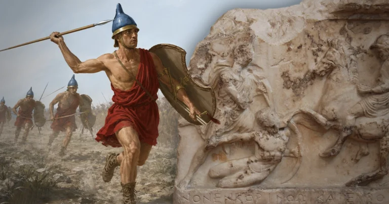

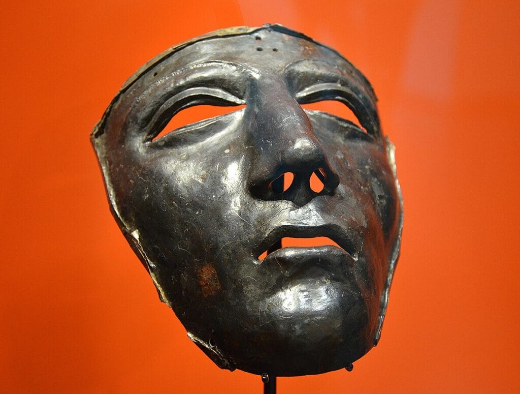
Among the roughly six thousand Roman military objects recovered from the agricultural fields and peat edges around Kalkriese in Lower Saxony, Germany, one stands out with particular force. It is a silvered iron face mask, originally attached to a parade helmet, depicting a calm, almost serene human face with closed eyes. It was found during the systematic excavations that began at the site in 1987. The soldier who wore it probably used it for military exercises and ceremonial reviews rather than actual combat, which makes the context of its discovery more striking: it was recovered from the ground where Legio XVII, Legio XVIII, and Legio XIX of the Roman imperial army were effectively annihilated over the course of several days in September 9 CE. This was the Battle of Teutoburg Forest, the clades Variana or Varian Disaster as Roman historians called it, and it remains one of the most studied military catastrophes of the ancient world. The question of how Arminius pulled it off, and exactly what combination of terrain, deception, timing, and tactical coordination made it possible, has occupied scholars for two millennia and archaeologists for the past thirty-five years. This article covers the political setup, the mechanics of the ambush, what the archaeology has revealed, and why the scholarly debate over the site still matters.
Arminius: A Roman Officer Who Never Stopped Being Germanic
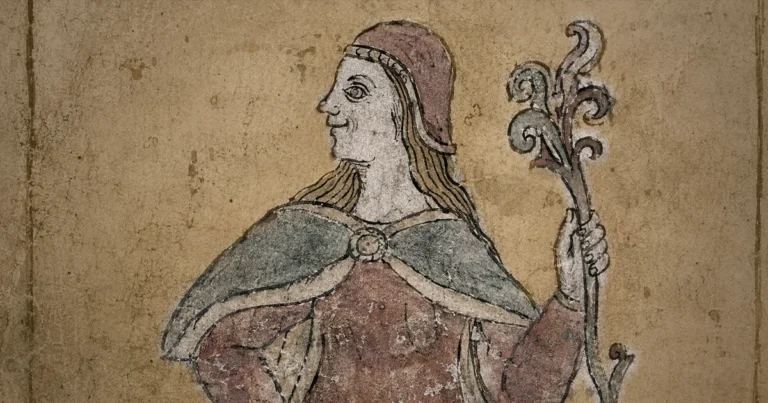
The most important factor in Arminius’s success was not the weather, the terrain, or even the coalition he assembled. It was his personal position inside the Roman command structure. Arminius, son of Segimer, was a chieftain of the Cherusci tribe who had been given to Rome as a diplomatic hostage in childhood, a practice the Romans called obsides, through which they extracted elite Germanic youths and returned them as Romanized allies. Arminius grew up in the Roman military. He learned to speak Latin and to read it. He reached the rank of equites, the Roman equestrian order, the second tier of the Roman social hierarchy, and commanded an auxiliary unit that fought under Roman standards. He understood the Roman order of march, the Roman camp layout, the Roman command signals, and the Roman habit of taking seasonal routes back to winter quarters. No external enemy of Rome that century had that advantage.
In the summer of 9 CE, Arminius was serving as a military advisor to Publius Quinctilius Varus, the Roman governor of the newly organised province of Germania between the Rhine and the Elbe. Varus was an experienced administrator, a former governor of Syria, and the son-in-law of the late Marcus Agrippa, Augustus’s master general. He was not a military fool. His crime was not stupidity but misplaced trust. Arminius had spent months or years feeding him a carefully constructed picture of local cooperation, Germanic goodwill, and manageable administration. When Varus moved his three legions toward the Rhine for winter quarters in early September, he accepted Arminius as his guide through country that was not yet fully mapped. Velleius Paterculus, writing a generation later and relying on eyewitness testimony, describes Varus as a man who “entered the heart of the country as if among a people enjoying the blessings of peace.” He did not send scouting parties ahead. He did not keep the legions in close marching order. He let the column stretch.
Segestes, a senior Cherusci nobleman and Arminius’s father-in-law, warned Varus that a conspiracy was being organized. Varus dismissed the warning as the product of personal rivalry between the two men, which it partly was. Segestes had opposed his daughter’s marriage to Arminius and had political reasons to undermine his son-in-law’s standing. Varus read the warning through that personal lens rather than the military one. Once Arminius left the column, ostensibly to gather allied warriors to assist the Roman march, the trap was already closing.
Three Legions on the March in September 9 CE
The Roman column that set out that autumn represented a substantial fraction of Augustus’s entire military capacity. Legio XVII, XVIII, and XIX, each nominally five to six thousand men, marched together with six cohorts of auxiliary infantry, three squadrons of cavalry, and the enormous baggage train of animals, wagons, civilian followers, and camp servants that accompanied any Roman army on a seasonal relocation. Modern estimates of the total number of people in the column range from around fifteen thousand combatants to a total of twenty thousand or more including non-combatants. Cassius Dio, whose Book 56 of the Roman History provides the most detailed surviving account of the disaster, describes a force that included women, children, and enslaved persons marching with the column. The two golden finger rings recovered at Kalkriese, sized for female hands and depicting the mythological figures Pegasus and Silenus, are physical confirmation of Dio’s claim: there were civilians in that column, and they too did not survive.
The Roman marching order for a column through contested or partially known territory prescribed specific formations. Scouts advanced on the flanks and ahead of the main body. Engineers moved in front to widen paths and stabilise the ground. Heavy infantry units marched in defined blocks with standard intervals between them to allow rapid deployment into combat formation if attacked. Baggage moved in the rear third of the column under cavalry protection. When a Roman army operated as it was designed to, this formation could compress quickly into a fighting posture along almost any line of attack. The problem in September 9 CE was that the column did not hold these prescribed intervals. Cassius Dio states explicitly that the soldiers were scattered and that the baggage was intermingled with the fighting units, which suggests that the column had already relaxed into a transit pattern rather than a march-to-contact formation before the attack came.
Rain and difficult ground played a role in this, and the ancient sources say as much. Publius Annius Florus, writing in the early second century CE, describes rain and wind beating into the soldiers’ faces as they moved through the forest. Cassius Dio describes the trees as close and very high, the ground broken by ravines, the roads needing constant engineering work as the column advanced. But Dio himself, as the scholar Jona Lendering of Livius.org has noted, was drawing on geographical conventions about the Germanic world as a place of primeval forest, and his description may be more literary than topographical. What the archaeology confirms is more specific and more damning: the column had reached a narrow geographic corridor where it could not manoeuvre at all.
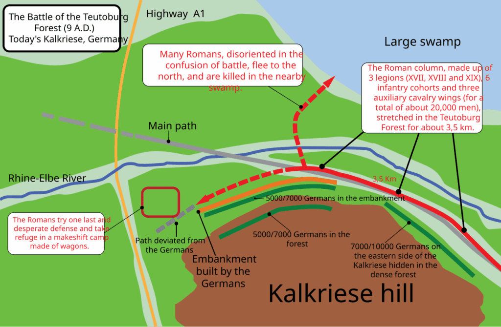
The Saltus Teutoburgiensis: A Narrow Pass, Not a Deep Forest
The Latin name for the site where the disaster occurred, Saltus Teutoburgiensis, is significant and routinely mistranslated. The word saltus does not mean forest in the sense of dense woodland. It means a narrow pass or defile, a pinched corridor between obstacles. The Romans themselves used the term for geographic bottlenecks in mountain country, and there is a strong argument, made explicitly by Jona Lendering at Livius.org, that the name should be rendered as the Teutoburg Narrows rather than the Teutoburg Forest. This is not a pedantic distinction. It changes the tactical picture entirely. The disaster did not happen because an army blundered into impenetrable wilderness. It happened because an army was guided into a specific narrow corridor where the geographic constraints prevented the one thing a Roman marching column most needed: room to pivot, form up, and fight.
The corridor at Kalkriese, as excavated by the joint archaeological project of the universities of Osnabrück and Munich together with the Museum und Park Kalkriese, measures roughly 220 metres wide in its narrowest section. To the north lay the Großes Moor, the Great Bog, a large area of low wetland where the ground could not support the weight of soldiers in armour and formation. To the south rose the Wiehengebirge, the Wiehen Hills, a wooded ridge whose northern slopes fell away steeply toward the corridor. A Roman force trying to escape north would sink. One trying to escape south would climb into waiting attackers on higher ground. The column had to advance westward along the narrow strip between the bog and the hills, and that strip was where the Germanic coalition had prepared its trap.
Along the southern edge of that corridor, Arminius’s coalition had constructed a rampart. Early excavations identified this as a turf-and-sand wall approximately 700 metres long and 1.5 metres high, with a wooden palisade on top and gates at intervals. Behind the wall, fighters could hurl javelins and sling stones at the compressed Roman column and then withdraw quickly through the gates before a Roman counterattack could form. The wall did not need to stop a charge. It needed only to force the Romans to halt while missiles came in from one side, while the bog prevented any envelopment on the other. It was, in its engineering logic, simple and devastating. Recent geoarchaeological work by Joachim W. Härtling and colleagues at the Oberesch section of the site, using optically stimulated luminescence and radiocarbon dating on excavations conducted between 2017 and 2019, has raised questions about whether some of the structures attributed to the Roman period are in fact medieval in date. That debate is ongoing, and it has not undermined the identification of Kalkriese as the battle site, but it has forced a more careful re-examination of which specific earthworks can be confidently dated to 9 CE.
Built out of a love for history, kept free from distractions.
Spoken Past is an independent project shaped by curiosity, care, and long hours of research. Reader support helps keep it maintained, carefully researched, and open to everyone.
The Battle of Teutoburg Forest in the Archaeological Record
When Major Tony Clunn, a retired British Army officer and amateur metal detectorist, obtained permission to survey farmland near Kalkriese in 1987, he was hoping, as he later wrote, to find “the odd Roman coin.” Within hours he had recovered three ovoid lead sling bolts, and within days the pattern of finds expanded rapidly. Clunn reported his discovery to the authorities, which initiated a professional excavation under Professor Wolfgang Schlüter of the Kulturhistorisches Museum Osnabrück, beginning in 1988. Since 1990, excavations have been directed by Susanne Wilbers-Rost of the Museum und Park Kalkriese. Since 2016, the universities of Osnabrück and Munich (LMU) have collaborated in targeted excavations of specific sections of the battlefield, using ground-penetrating radar, drone photogrammetry, and magnetometry to identify concentrations of metal before digging.
The results are extraordinary in their density and variety. Museum und Park Kalkriese now holds over six thousand Roman military objects recovered from the site, spread across an excavation area of approximately fifty square kilometres. The finds include Roman swords and daggers, javelin heads, arrowheads, sling bolts, helmet fragments, hobnails from soldiers’ sandals, belt fittings, chain mail fragments, and armour plate sections. Among the most striking individual objects are a plumb bob inscribed “CHOI,” standing for “Cohortis I” (property of the first cohort), a chain mail fastener stamped with the name Marcus Aius and his unit designation, and a nearly complete set of lorica segmentata plate armour recovered in 2018 from the northern edge of the site alongside a dagger and a spear. The spatial distribution of finds is itself informative. As Stefan Burmeister, managing director of the museum, has explained, the clustering of objects along identifiable lines of movement allows archaeologists to trace where different parts of the column made their final stands.
Human skeletal remains have been found in five bone pits, and the bones carry clear evidence of battle injuries including sword cuts and crush fractures. The remains are exclusively male, with no identifiable Germanic bones among them, which reflects both the Germanic practice of removing and honouring their own dead and the fact that many Germanic fighters wore Roman equipment obtained from previous raids and tribute arrangements and would be archaeologically indistinguishable from Roman soldiers. Eight gold coins of the Gaius-Lucius type (minted between 2 BCE and 4 CE to honour Augustus’s adopted grandsons) were found clustered together in 2016 within the core excavation zone, suggesting they were in a leather pouch carried by an officer when he died. Their presence, combined with the total absence of coins minted after 9 CE anywhere at Kalkriese, provides one of the strongest chronological pins for the site’s identification as the battle location. The finds collectively span a corridor almost twenty-four kilometres from east to west, which indicates the battle unfolded over several days as the column advanced and then fragmented.
The silver-plated iron face mask is now the emblem of the museum. It was designed to be attached to a helmeted head during cavalry exercises and ceremonial parades, not worn in battle, which makes its presence on the battlefield a reminder that the soldiers who died here were not raw recruits on a frontier skirmish: they were the professional, highly equipped heart of the imperial army. As World Archaeology noted in its analysis of the ongoing Kalkriese excavations, it is the combination of the density of finds, the precise geographical corridor, and the consistent Augustan-era dating that makes the battlefield identification essentially secure, even as specific structural elements within the site continue to be debated.
What the Ancient Sources Say and Where They Disagree
The textual evidence for the Battle of Teutoburg Forest comes from four main ancient authors, each writing at a different remove from the events. Velleius Paterculus, writing around 30 CE in his Compendium of Roman History, is the closest in time. He served in the Germanic campaigns himself and knew veterans of the disaster personally. His account is emotional and brief, blaming the disaster almost entirely on Varus’s credulity and Arminius’s treachery, but it provides the chronological anchor for the other sources. Publius Annius Florus, writing around 130 CE, gives the most rhetorically embellished account, describing the savagery of the Germanic fighters who cut out the eyes of Roman prisoners and sewed shut the mouths of lawyers.
The fullest narrative account comes from Cassius Dio, the Greek-born Roman senator and historian who wrote his eighty-volume Roman History between approximately 211 and 233 CE. His account of the battle in Book 56 describes the terrain, the weather, the collapse of the Roman formation, and the final suicide of Varus, and it is detailed enough to have generated two centuries of scholarly argument. As scholars working with the Livius.org ancient history reference project have pointed out, Dio was writing two centuries after the events and working from sources he does not name. His description of dense impenetrable forest, ravines, and unpassable mountains fits the ancient literary convention for Germany as a primordial wilderness rather than the actual topography of Kalkriese, which is relatively flat lowland terrain. Dio is reliable on the political causes and tactical outline. He is less reliable on the physical geography, and the archaeology should take precedence over his landscape descriptions for that specific question.
Tacitus, writing around 117 CE, did not describe the battle itself because his Annals of Imperial Rome begins with the death of Augustus in 14 CE, five years after the disaster. But in Annals Book 1, chapters 60 to 62, he describes the later visit of the general Germanicus to the battlefield site, which provides an unforgettable image of the aftermath: scattered bones, whitening in the open ground, fragments of spears and horses’ limbs, skulls nailed to trees, and the remains of the roughly built camps where each surviving night had begun. The passage is partly propaganda, designed to position Germanicus as heroically fulfilling the duty Tiberius had neglected. It is also almost certainly based on Pliny the Elder’s lost History of the Germanic Wars, which drew on interviews with survivors. Whatever its literary purpose, it fixes the aftermath in a way no later text can match.
How Three Legions Fell Apart Over Three Days
The mechanics of the ambush’s success require precise description. The Germanic coalition did not field an army comparable to Rome’s in equipment or training. They had no siege weapons, no heavy infantry formations, no cavalry to match the Roman auxiliary horse. What they had was local knowledge of the ground, a prepared position on the best chokepoint in the corridor, and the enormous tactical advantage of attacking a column that could not deploy. The Roman legionary fighting system was designed around the ability to form a battle line, to advance in formation, to use the large scutum shield for collective defence while throwing pila with the other arm, and then to close with the gladius. All of that required space and time. In a 220-metre-wide corridor with bog on one side and a rampart pouring missiles on the other, there was neither.
The Germanic fighters operated from the rampart and from the forested slope, attacking the column at multiple points simultaneously, withdrawing before a Roman response could form, and then returning. Rain degraded the effectiveness of the Roman slingers and the accuracy of javelin throws, and it made the Großes Moor edge even more treacherous for soldiers who might otherwise have tried to push through the boggy ground to establish a broader front. Each nightfall produced a fortified Roman camp, because military doctrine was too deeply drilled to abandon, but each morning resumed the same impossible march through the same impossible corridor. The Romans burned their wagons on the second and third days to remove the impediment to movement. They abandoned their baggage and wounded. By the third day, Cassius Dio records, the column had lost its cohesion, its officers were dead, and Varus himself, wounded, chose to die on his own sword rather than be taken prisoner.
The loss of the three legionary eagles, the aquilae that represented the honour and spiritual existence of the units, was its own catastrophe. Roman armies could be rebuilt. Legionary standards could not simply be replaced; they had to be recovered. Augustus, according to Suetonius’s Life of Augustus, was so disturbed by the news that he pounded his head against the wall of his palace and cried out “Quintili Vare, legiones redde” (Quinctilius Varus, give me back my legions). Two of the three eagles were eventually recovered in later Germanic campaigns: one by Germanicus in 15 CE and one in 16 CE. The third was reportedly still missing when Publius Annius Florus was writing, several decades after the event.
Strategic Consequences and the Limits of Roman Expansion
The immediate consequences of the Battle of Teutoburg Forest were severe. The Germanic coalition swept east of the Rhine, eliminating every Roman fort, garrison post, and civilian settlement. Two legions under Varus’s nephew Lucius Nonius Asprenas held the Rhine line and prevented an invasion of Gaul, but the province of Germania, which Varus had been in the process of organising along normal Roman administrative lines with law courts and census registration, ceased to exist as a Roman administrative entity in a matter of weeks. Velleius Paterculus, who served in Germany after the disaster, records that Asprenas’s decisive action in holding the Rhine was crucial. Without it, the revolt could have spread into the settled parts of the western empire.
Augustus immediately conscripted freedmen (formerly enslaved individuals) into the military, a measure of desperation that the Romans associated with the darkest moments of the Hannibalic Wars. He extended the term of service for existing provincial governors in case of further disruption. Germanic punitive campaigns followed under Tiberius and then under Germanicus between 14 and 16 CE, with Germanicus pressing deep into Germanic territory and inflicting significant losses in a series of hard battles. But a permanent Roman presence east of the Rhine was never re-established. The Rhine became the effective frontier of the western empire, a line maintained for the next four centuries. The historian Adrian Murdoch, whose book Rome’s Greatest Defeat remains one of the most accessible modern accounts of the battle, has argued that the long-term strategic consequence was the preservation of a German-speaking cultural zone east of the Rhine that would otherwise have been absorbed into the Latin-speaking world of the Roman empire.
The later appropriation of the battle as a German national founding myth began in the Renaissance, when the humanist scholar Conrad Celtis identified Arminius as an ancestor of the German people from Tacitus’s account. In the nineteenth century, this identification intensified enormously, and the figure of Arminius was germanised into “Hermann,” the national hero whose enormous neoclassical statue in the Teutoburg hills near Detmold, the Hermannsdenkmal, was completed in 1875. That statue places the battle at the wrong geographical location and frames it in political terms that would have been completely foreign to anyone in 9 CE. The archaeological site at Kalkriese, fifty kilometres to the north, tells a different and more complicated story about the Battle of Teutoburg Forest: not a heroic national resistance but a precise military deception, a terrain trap, three days of grinding combat, and a Roman army that died in a place it could not see clearly and could not escape quickly.
Primary sources: Cassius Dio, Roman History Book 56.18-22 (c. 220 CE); Velleius Paterculus, Compendium of Roman History 2.117-120 (c. 30 CE); Publius Annius Florus, Epitome 2.30 (c. 130 CE); Tacitus, Annals 1.60-62 (c. 117 CE). Secondary sources: Jona Lendering, “Kalkriese,” Livius.org; “Uncovering Kalkriese,” World Archaeology (2021); Museum und Park Kalkriese, Permanent Exhibition and Research, Bramsche, Lower Saxony; Joachim W. Härtling et al., “New Geoarchaeological Evidence at the Oberesch Site, Kalkriese,” published in review (2024); Adrian Murdoch, Rome’s Greatest Defeat: Massacre in the Teutoburg Forest (Sutton Publishing, 2006); Herbert W. Benario, “Arminius into Hermann: History into Legend,” Greece and Rome 51, no. 1 (2004): 83-94.